Trail Information
Trail Name: Dawson Butte Ranch Open Space Trail
Location: Near Larkspur, Colorado
Date: December 25, 2019
Time at the Trail Head: 2:00 pm
Trail Length: 4.6 miles
Elevation Gain: 374 feet
Elev. at Trail Head: 6,828 feet
# of Hikers Passed: 11
# of Mnt. Bikers Passed: 0
# of Horses Passed: 3
Mosquitoes: 0
Trail Research
I started this day out planning on going to the Devil’s Head Lookout trail but the access roads have been closed for the winter, so after being stopped by gates twice, I decided to head to a different trail.
Some friends had recommended the Dawson Butte Ranch Open Space trail, and since it is near my house, I thought I would try it out as my second option, and I am sure glad I did.

Drive to the Trail
The road to trail is one of my favorite to take in this area. It is Perry Park Road or Colorado State Highway 105. It is a wonderful drive from Sedalia to Palmer Lake, Colorado. It’s a nice relaxing drive situated at the base of the Rocky Mountains and the road winds through ranch land, homes and pine tree forests.
This is an area that my wife and I are seriously considering moving to in the near future.
My Day on the Trail
The trailhead parking lot is large and has two parking lots, one for cars and the other for horse trailers. There are also bathroom facilities at the trailhead.
It’s obvious that a lot of people use this trail to ride their horses, due to all the horse tracks that were visible. The horses tend to make the trail more muddy but probably 90% of the trail was dry and great to hike on.
I hiked the trail counter clockwise but I would recommend hiking it clockwise because, if you go left on the trail at the trailhead, you will hike alongside a road for a good mile and a half and this part of the trail has more snow, ice and mud then the remainder of the trail. I like to leave the best for last so remember to hike this one clockwise.
On north section of the trail, you will see some great views of Dawson’s Butte and also have some nice views of open fields with forests in the background with the foothills of the Rockies beyond that. The trail is muddy in some location so make sure you wear some waterproof boots, as this will make your hike much more enjoyable. I say this because my wife does not have waterproof boots yet and she hates going on trails like this as she has to walk carefully around a lot of areas, which makes here a little irritated.
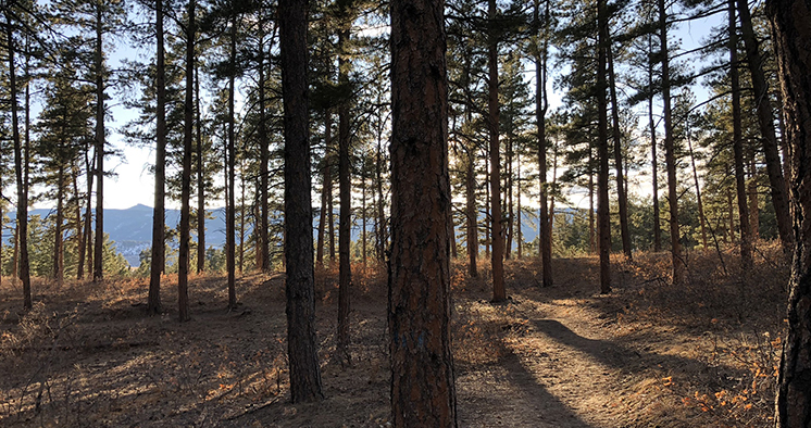
Once you get to the northwest and west sections of the trail, you will enter some gorgeous pine tree forests. You won’t have many views of the mountains but the views in this forest are spectacular.
One of the reasons I like this forest so much is that the trees aren’t extremely close together and there is not a lot of brush on the forest floor, so you can actually walk on the bed of pine needles below the pine trees and not worry about being on the trail the entire time.
Some of you may not think this would be a great scenic area but I challenge you to take your time and stop at different locations to see if the forest beauty rubs off on you. I think you will grow to love how relaxing and comfortable this forest makes you. There are even some benches and picnic tables to stop and have some lunch, if you feel up to it.
Also, there is hardly any areas that are muddy and snow covered or hard to pass due to horse tracks (muddy tracks due to the horses) which makes this an extremely enjoyable hike.
There were several times on this hike when there were no mountain views, but I had to stop and take in the beauty of this Colorado forest. There are so many trails I have taken where the forest is thick and you can’t see much of anything while walking in it, but that was not the case in this forest.
I probably spent an extra hour taking my time to wander slowly underneath the pine tree canopy. I walked off the trail several times to meander around the trees and over the beds of pine needle.
There is only 374 feet of elevation change on this trail so it is essentially flat, even though folks that are not use to hiking at 6,000 feet may find they get winded a little as they hike up the trail.
The trailhead is actually the high point on trail so you have to hike down in elevation, no matter which way you go. The trail is 4.6 miles long, so give your self enough time to make the hike, plus be able to stop and enjoy the scenery without having hike quickly to get back to your vehicle.
I took more time on the trail to relax and enjoy the forest, plus to take pictures and videos, so the sun set on me before reaching my truck, but that also gave me a few nice photos of the setting sun over the Rocky Mountains.
Trail Recommendations
This is another one of those trails that I ended up loving, after I assumed it wouldn’t be that impressive. It’s great that there are so many trails with a variety of scenery here in Colorado that there is a trail for everyone.
I did not need my ICETrekkers on this trail but having a great pair of waterproof boots is essential and my Leki trekking poles helped me a lot as I as hiking quickly at the end, up hill, to the parking lot. I wear the Oboz Bridger Mid B-Dry Waterproof hiking boots.
- Exclusive AERGON grip features a hollow core construction to save weight and create an edgeless, rounded grip for comfortable gripping at all angles especially for "palming" on steeper terrain. Thermo foam grip material for extra comfort, light weight and insulation in colder weather. Built in 8deg Positive Angle in LEKI grips keeps wrist in neutral position and provides more efficient pole plants.
- Air-textured "no bulk" security strap maintains design dimensions of grip; efficient wicking and fast drying; adjusts and secures strap adjustment without buckles. Extended foam grip for traversing and climbing. SPEEDLOCK 2 lever locking mechanism is simply THE strongest external locking system in the world as rated by TUV, and the only locking systems to meet the minimum holding force recommended by TUV.
- 100% High Modulus Carbon shaft sections for reliable, lightweight performance in all conditions. PE coated, Kevlar reinforced tension cord for long term reliability. ELD (External Locking Device) gives easy access to release the assembly tension of the pole for quick knock down and packing. Maximum tension between shaft sections made possible by internal (serviceable) spring in lower shaft.
- Carbon section ends are protected by machined Aluminum sleeves for extra long wear. Machined Aluminum connectors help to center shaft sections for quick, snag free assembly. LEKI's original Carbide Flextips provide secure hold on all terrain and surfaces for years of adventure; easily replaced in the field.
- Interchangeable basket system allows a variety of different sized LEKI baskets to be easily screwed on/off for different seasons/uses thanks to offset threads that keep the baskets securely in place.
- 100% Leather
- Made in the USA or Imported
- Rubber sole
- Shaft measures approximately 4.5" from arch
- Heel measures approximately 1.5"
Check out this short video of the Dawson Butte Ranch Open Space Trail on YouTube.
I would love to know if you have had any experience on this trail or have other trails you love to hike. Leave a Comment Below or send me an Email.
Return to Home Page
- Platform boots heel height: 8 cm/3.15", platform height: 2 cm/0.79", shaft height: 37.2 cm/14.65", opening: 39 cm/15.35"
- Premium faux leather upper and soft microfiber fabric lining, the cushioned padded insole can rest assured.
- Square-toe block heel boots feature side zipper closure with stretch gore closure, easy to put on and take off.
- Classic casual design, suitable for you to wear on a variety of occasions such as daily casual, formal business and so on.
- If you find any problem with the SOVANYOU shoes, please feel free to contact us, we will help you within 24 hours!
- Latest Fashion and Trend for Stylish and Sexy look
- Platform measures approximately .75", Shaft measures approximately 5.5”
- Ankle Bootie on a LUG SOLE STACK BLOCK heel (approximate 1.50” height)
- Wide stretchy elastic side panels gore for easy in and out
- Available in whole sizes only. If between sizes, please order 1/2 size down from your usual size.
- 17mm Twinface sheepskin upper
- 17mm sheepskin lining and insole
- Treadlite by UGG outsole for comfort
- Topically applied water repellency treatment
- CHALET BOOTS — The sweetest boots to complete all her outfits.
- FABRIC — Made of 100% polyester microsuede
- CLOSURE — Pull-on style
- DESIGN — Features cozy faux fur trim, buckle detail at side and man made outsole
- NOTE – These boots are not intended for extreme weather conditions.
- Heel Height: 2.5", Platform Measures: 0.25"(approx)
- Shaft Height: 15"(approx)
- Fishished with a slightly padded faux fur insole, zipper closure for easy on and off.
- Top opening circumference: 14" (approx)
- Padded faux fur lining and insole


Wow! What an amazing trail you have at Dawson Butte Ranch. But by the way, how long do you need to hike a 4.6 mile trail? I also want to try doing it with friends. In addition to refreshing as well as exercising, let alone the place that you show is very beautiful plus there are no mosquitoes. Because I have experience on trail in Morgan Lakes, there are so many mosquitoes that I feel very disturbed. Indeed the view that is served is very beautiful, but due to mosquito bites, it makes me stressful along the trail.
And one more thing, for your recommended Oboz Bridger Mid B-Dry Waterproof shoes, can I use it for snowy trail terrain?
Thanks
I would give yourself at least 30 minutes per mile, as you will stop and enjoy many great views, so that would take you approximately 2.5 hours to 3.0 hours.
I have used the Oboz Bridger hiking boots on probably 10 trails in the last two months and all of them have had some amount of snow. I was on one hike this last week at Badger Mountain, about 1 hour west of Colorado Springs, and there was between 1 to 1.5 feet of snow and my feet stayed warm the entire time. I also wear Kull Silencer hiking pants and I never had any snow get into my boots.
I would recommend snow shoes and Gaters if you plan on hiking in significant snow.
Let me know if you have any other questions.
Rick
It’s amazing how much beauty you can find in a relatively small part of the world. You seem to be basking in all of it. I really am glad you share the photos and videos of your hikes. For people like me, who live in not-so-scenic parts of the US, it’s lovely to watch and enjoy the explorations of others. Your photographs are true quality, as well. You must use a high-quality camera. My photos are never that impressive. Please keep sharing. I love your website!
Well, thank you so much for the compliments and I’m glad you like the trail reviews on my site.
There are so many different types of scenery and vegetation in Colorado so you can see anything from farm land, ranch land, forests, mountains, rivers, sand dunes and much more. I truly love living here.
I have to be honest with you and tell you that I take all of my photos and videos with an iPhone 6. I am amazed at the quality of the images myself. I will be upgrading to an iPhone 11 at the beginning of the year and supposedly, the photos and videos are supposed to be even better.
I want to purchase a GoPro camera or something like it soon but for now I’m sticking with my iPhone.
Rick
As one who has driven through the Rockies a few times I can attest personally to Colorado’s unique and beautiful landscape. As such I am definitely interested to learn about some recommended hiking trails. I have not had the chance to visit Dawson Butte and I must say it sounds pretty wild with a mix of hikers and horses, and the views look amazing. This sounds like it would be a hike that pretty much anyone would be able to enjoy as it is pretty flat. Thanks for the recommendation and I will definitely check out your boots link as well, excellent work!
Thanks for the personal recommendation and experience you shared from your trips to Colorado.
This trail, like many others in the Front Range of Colorado, are great for beginners to experienced hikers. This one is especially nice because it is almost completely flat.
There is another trail about 4 miles away to the south called Spruce Mountain that has an elevation gain of around 600 feet but once you reach the top of the bluff, it is loop trail that is completely flat and has some great views of the area.
Rick
You live in a beautiful country. This area reminds me of an area near my hometown in South Africa, Barberton. We also have a lot of forest which to hike in. My husband and I started walking to get fit. Your post inspires me to challenge ourselves to maybe take a hike when we are fit enough. Beautiful pictures.
I am glad I was able to encourage and inspire you to get outdoors more. I would love to visit South Africa some day, so I will make a note to see the area around Barberton.
Don’t wait to get fit to go on hikes. You can start easy and work your way up. I have some family and friends who come and visit me here in Colorado and other then them getting use to the altitude, I take it easy on them and take them on shorter trails and not to high in elevation until they have been here at least a week so they can get use to the altitude.
Thanks for stopping by.
Rick
I am going to visit my sister in Colorado next summer, I think we will add this to our itinerary! It looks like an amazing hike, but not too tough, I think we’ll bring the kids too. Plus having a lunch at one of the picnic tables you mentioned would be perfect. Thank you so much for sharing about your hike, I can’t wait to take our own!
Hi Travis. That’s great to hear you will be visiting Colorado. There are many trails that are easy to hike in the area. I have several more of them here on my website. You can also use AllTrails to find some that work well for you and your family.
Let me know what trails you take when you get here.
Rick