Trail Information
Trail Name: West Spanish Peak Trail
Location: Near Cuchara, Colorado
Date: May 17, 2020
Time at the Trail Head: 6:00 am
Trail Length: 7.9 miles
Elevation Gain: 2,624 feet
Elev. at Trail Head: 11,257 feet
# of Hikers Passed: 35
# of Mnt. Bikers Passed: 0
# of Horses Passed: 0
Mosquitoes: 0
Trail Research
I have driven by the Spanish Peaks mountains in southern Colorado many times, just southwest of Walsenburg and was waiting for the day that the snow would clear and make this hike possible. May finally arrived and the Spanish Peaks were clear of snow so it was time for me to hit the road.
I pulled up AllTrails and found the trail. It was an easy trail to follow, as I would find out that it was straight up the mountain.

You can see from the trail profile above that the first several miles were pretty easy to hike. The problem comes around the 12,000 foot elevation mark, at the tree line, when the trail goes straight up the ridge line. And I’m not joking, it looked to me that it was straight up.
Drive to the Trail
The drive past Colorado Springs is always beautiful, so I will only show some of the photos when I was closer to the mountain.
The only thing I will add is that I was almost killed when I was heading south out of Colorado Springs. I was driving about 80 mph in a 75 mph, when I noticed a state patrol car parked on the side of the highway, so I eased up on my speed, checked my mirror, turned my blinker on and started moving into the left lane. I was about half-way into the left lane when a mustang flew by me like I was standing still and could have only missed hitting my by about 1 foot. My guess is that the person was traveling around 150 mph. Well, after I caught my breath, realized that I wasn’t upside down in a ditch, I could see that the chase was on, as the state trooper took off in a hurry. I never did hear if they caught the person.
I was driving through Colorado Springs around 4 am as I always like to get to the trail at sunrise, so the drive was mostly in the dark until I passed through Walsenburg. The skies were clear but the Spanish Peaks were enshrouded in clouds as you can see from these pictures. The clouds had just started to clear as I drew closer to the trailhead.


It turned out to be a spectacular day as the clouds burned off and here are a few photos after I left the trailhead.

Here is what the Spanish Peaks look like from the north side of the mountains.

My Day on the Trail
Ranger and I hit the trail as soon as we arrived. I love getting shots of the hike when the clouds are lifting or burning off. The clouds only hung around for about 20 minutes after we hit the trail but it is always great to see the sun rise through the morning clouds or fog.


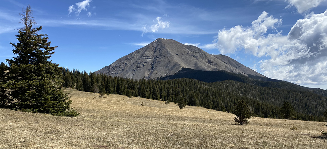
I don’t think we had hiked more than about 1/2 mile when we came to an open meadow with a great view of the West Spanish Peak with the sun starting to burn off in the valley below.


The next two miles of the trail was generally flat with a slight down hill grade. This is always nice, until you realize you will have more elevation to climb, eventually.
We kept on hiking and had re-entered the pine tree forest, but were still able to get some nice shots of the mountains. You’ll notice Ranger in several of these photos. He is my hiking buddy and is always alert to people and animals, which makes me feel more safe.


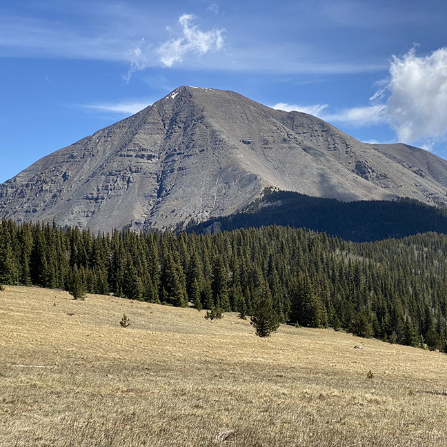
This next photo is looking northeast towards Walsenburg with the West Spanish Peak on the right side of the photo.

And here is a close up view of the same area.

Here’s Ranger, waiting and looking back down the trail as some hikers were coming up behind us.

It’s crazy to think that someone left him and his siblings in a box alongside of the road. We were lucky enough to have found him at an animal shelter and rescued him. It only cost us $30 and to think, we use to spend hundred’s of dollars on dogs when we were younger. Ranger has been the best dog we have every had the privilege to have in our family.
We were finally getting high enough that we could see some great views of the Rock Mountains to our west.

We were also beginning to see just how steep the climb was going to be to get up the West Spanish Peak.

Here is a nice panorama photo of the area.

We were finally nearing the tree line which was about the 12,000 foot elevation level.

Here is another nice view out to the west.

You can get a sense of how I was feeling at 12,000 feet, looking straight up that ridge line and saying “Hell No.” It’s no wonder everyone I saw passing me on the trail only had about 6% body fat and were in the best shape of their lives.

This next photo really does a better job of showing you about how steep this section of the trail was.

This is the time I sat down with Ranger and we both decided that 12,000 feet was high enough for this gorgeous Colorado day. We took some time to enjoy the grand views.

We started heading back down the mountain but made sure to get some more fantastic photos.

We had finally arrived back at the large meadow within 1/2 mile of the truck and turned around to take in some last moments of this incredible trail.


We arrived back at the truck and were finally able to get a few photos of the trailhead. The clouds had burned off by this time. I tried the door to the bathroom facilities but for some reason they were locked. It seems about half of all the bathroom facilities are closed in Colorado and you never know for sure if the one you are hiking at will be open, so be prepared.


Trail Recommendations
This is an easy trail for the first 2 miles, but then turns into a freaking hard hike from 12,000 feet to the summit, so be prepared for the altitude and the steep climb.
I enjoyed the drive to the trail as well as the trail. I only wish I would have been in better shape to make the summit.
A Town to Visit
There was a great little town you should allow some time to visit on your return trip from the mountains. The town is called Cochara, Colorado.


Always allow time to stop and enjoy some of the local flavor of Colorado. I have always been thankful that I did.
One last recommendation for my hike up the West Spanish Peak. Make sure you have some good trekking poles. I am not kidding you when I say that everyone from young to old, had trekking poles on this hike.

- Exclusive AERGON grip features a hollow core construction to save weight and create an edgeless, rounded grip for comfortable gripping at all angles especially for "palming" on steeper terrain. Thermo foam grip material for extra comfort, light weight and insulation in colder weather. Built in 8deg Positive Angle in LEKI grips keeps wrist in neutral position and provides more efficient pole plants.
- Air-textured "no bulk" security strap maintains design dimensions of grip; efficient wicking and fast drying; adjusts and secures strap adjustment without buckles. Extended foam grip for traversing and climbing. SPEEDLOCK 2 lever locking mechanism is simply THE strongest external locking system in the world as rated by TUV, and the only locking systems to meet the minimum holding force recommended by TUV.
- 100% High Modulus Carbon shaft sections for reliable, lightweight performance in all conditions. PE coated, Kevlar reinforced tension cord for long term reliability. ELD (External Locking Device) gives easy access to release the assembly tension of the pole for quick knock down and packing. Maximum tension between shaft sections made possible by internal (serviceable) spring in lower shaft.
- Carbon section ends are protected by machined Aluminum sleeves for extra long wear. Machined Aluminum connectors help to center shaft sections for quick, snag free assembly. LEKI's original Carbide Flextips provide secure hold on all terrain and surfaces for years of adventure; easily replaced in the field.
- Interchangeable basket system allows a variety of different sized LEKI baskets to be easily screwed on/off for different seasons/uses thanks to offset threads that keep the baskets securely in place.
Check out this short video of the West Spanish Peak trail on YouTube.
I would love to know if you have had any experience on this trail or have other trails you love to hike. Leave a Comment Below or send me an Email.
Return to Home Page
West Spanish Peak Trail
Pros
- Grand Views
- Incredible Drive
- Mountain Views
- Cochara, Colorado
- Large Trailhead with Facilities
Cons
- Hard Hike from 12,000 to Summit
- No Water on the Trail
Wow, those pictures are absolutely beautiful! I wish I lived closer to Colorado because I would certainly make the trek to visit the West Spanish Peak Trail.
I love hiking and experiencing nature, but I’ve certainly never seen anything that pretty in person. At some point in my life I might have to make the journey out West to see some of these trails and more.
Hey Joe. It is much nicer to live here and be able to enjoy the mountains more. My struggle each week is to narrow down where I want to hike at. I always start with the weather and pick locations which are going to have the most clear skies as this helps the photos to be much better.
I hope you get to visit soon. Let me know when you do visit and I can give you some advice on trails to visit or even go on a hike together if you’re up for that.
Rick