Trail Information
Trail Name: Button Rock Mountain Loop
Location: West of Lyons, Colorado
Date: May 23, 2020
Time at the Trail Head: 8:00 am
Trail Length: 8.8 miles
Elevation Gain: 1,450 feet
Elev. at Trail Head: 7,287 feet
# of Hikers Passed: 35
# of Mnt. Bikers Passed: 13
# of Horses Passed: 0
Mosquitoes: 0
Trail Research
I was having some difficulty finding a trail in an area of Colorado that had some sunny weather and in an area that I had not previously hiked. I finally found what I thought to be a good trail west of Lyons, Colorado, called the Button Rock Mountain Loop.

So, I grabbed my gear and headed out.
I sometimes wonder if we get some kind of sense if we should take part in a particular activity because I had a sleepless night, and I felt like maybe I shouldn’t go on this hike. I will tell you now that nothing bad happened, but it seems like it was the wrong trail for me to pick, and my dog, Ranger, seemed to agree with me. More on that later.
Drive to the Trail
I got a late start to my hike on this particular Saturday. I had my alarm set for 3:30 am so I could get to the trailhead at sunrise, but I was having a lot of trouble getting my self out of bed. I finally left for the trail around 6:30 am and arrived at 8:00 am.
I was disappointed that the trailhead parking lot was nearly full and there were only 2 parking spaces remaining. This is one of the main reasons to get out of bed early, in Colorado. You may not find a place to park.
I have driven through this area many times and here are a few photos of the drive.
After passing though Boulder or Longmont, depending on the route you take, you’ll pass through the beautiful town of Lyons. Many people stop here along the way to Estes Park or the Rocky Mountain National Park (RMNP).
After about an 8-mile drive past Lyons, you exit to the left on a gravel road that takes you the rest of the way to the trailhead, oh, and the road follows a beautiful creek.
Actually, it’s called the West Fork Little Thompson River.
My Day on the Trail
I always want to arrive at the trailhead at sunrise as I am usually one of the first hikers there, plus it’s so beautiful watching the sun rise over the trail. On this day, I overslept and didn’t arrive until 8 am and was lucky to find one of two remaining places to park at the trailhead.
I should warn you that the trailhead is small and there are now bathroom facilities there.
The trail was busy right from the beginning with a lot hikers and mountain bikers. We were only about 30 minutes from Boulder so there are a lot of hikers from there and from the Denver area. I have a personal rule of never hiking withing 1.5 hours of Denver but I broke it on this day.
The trail was nice enough early in the day and in the shade of the mountain, but the temperatures were going to hit 84 degrees and that’s nice and warm here in Colorado, especially when your out on the trail for over 4 hours.
We rounded the first mountain and got our first glimpse of the Button Rock Mountain and where we would eventually be in a little more than 2 hours from now.

By this time, we had left the creek behind us so Ranger was relying on me to keep him hydrated.
We kept climbing up a ridge line and started getting better views of the surrounding area.
We started to see some of the Rocky Mountain National Park (RMNP) out to the west of us.
Up we kept climbing and started rounding the north side of Button Rock Mountain and were able to get a few views out to the north of us.
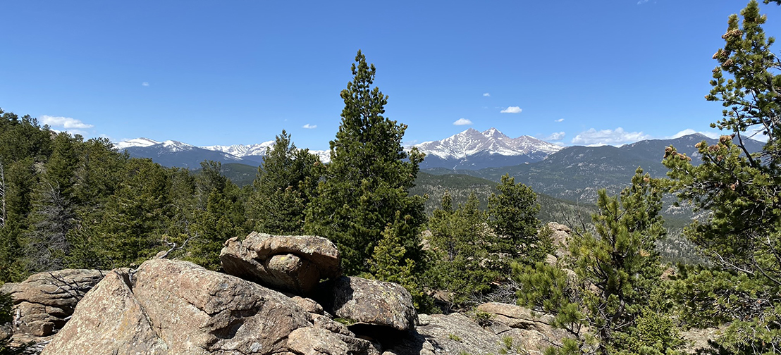
Here’s another glimpse of the RMNP. I believe this is Long’s Peak in the photo and it is one of the 14ers in the Park.
We finally made our way around to the east side of Button Rock Mountain and were able to see out to the southeast towards Boulder, Colorado.
We were near the high point on the trail and were getting some of the best vantage points looking out towards the RMNP with Estes Park on the right side of the photo, even though you can’t see it.
There are some great vantage points up here but they were not as grand as I was hoping for.
We had reached the high point on the trail and seen the best views of the say and were over 2.5 hours on the trail. Ranger and I were getting really warm and he was helping to drink up all the water I had packed in. As I mentioned earlier, there is only water down by the trailhead and nothing up top. The mistake I had made on this trip was packing enough water for me but not for an extremely thirsty dog.
We shared the water until we could get down the mountain but there was still a long way to go.
Another view of the Rocky Mountain National Park.
Ranger and I were really over this trail and wanted nothing more than to get off this mountain.
We were getting closer to the end of the trail but still had some nice views of Long’s Peak in the Rocky Mountain National Park.
The hike was nearly over when we finally found some water for Ranger and he was going to hang out and enjoy this for a while.
I think he emptied most of the stream from his drinking but he managed to find some more water and decided to cool off for about 5 minutes.

We finally reached the trailhead, and to my amazement, there were probably 50 more cars here than when I had arrived. One nice person had parked their red truck directly behind me and it was nearly impossible to get out of there.
Honestly, I was a little ticked off at this time and really have no desire to ever return to this trail, but of course it wasn’t over. I got one last glimpse of everyone parking on the road to get to this trail that really wasn’t worth the hiking adventure, in my opinion.
Trail Recommendations
There are so many great hiking trails in Colorado and this is not among them, so unless you’re bored and have nothing better to do, I would find one of the other thousands of trails that have more to offer.
Lessons Learned
I mentioned earlier that there wasn’t much water on this trail so make sure you take plenty of water, probably a water bladder in your pack, plus some extra water bottles, and don’t forget to pack extra water for your 4-legged friends.
- Premium taste-free, leak-proof reservoir with fast flow rate offers hydration on the go for hikers, backpackers, travelers and mountain bikers
- Secure SlideLock slides both ways to open reservoir easily and close it securely; handy pincher grip allows for easy one-handed filling
- The high mount quick-disconnect offers fast, easy access without having to dig down into a pack to attach or detach the drink tube
- Leak-proof shut-off valve instantly stops flow, stows reliably; HyFLO self-sealing bite valve improves flow along with large 5/16-inch drink tube
- To dry Big Zip reservoirs, first wipe the interioir with a towel, then prop the reservoir open with the SlideLock slider to let it air dry
Check out this short video of the Button Rock Mountain Loop on YouTube.
I would love to know if you have had any experience on this trail or have other trails you love to hike. Leave a Comment Below or send me an Email.
Return to Home Page


Thank you for your post. It is useful for me. I will have a business meeting in Colorado. The meeting will be about one afternoon. I think about doing something before or after meeting, but I don’t take time to do the research.
Here comes your article on Hiking Trails in Colorado. I love hiking, but never hike in Colorado. It is a nice idea to do some hiking in Colorado. The Button Rock Mountain Loop has the appropriate distance, 8.8 miles, for me.
Thanks for the advice on bringing water with me. I have a big water bladder and will bring it with me. Your suggestion on Platypus Big Zip Water Reservoir is sound one.
I’m glad I could help. Let me know how you like the trail after you hike it.
Rick