Trail Information
Trail Name: Upper Monument Canyon
Location: Colorado National Monument, Grand Junction, Colorado
Date: March 11, 2020
Time at the Trail Head: 7:30 am
Trail Length: 9.4 miles
Elevation Gain: 1,650 feet
Elev. at Trail Head: 4,755 feet
# of Hikers Passed: 25
# of Mnt. Bikers Passed: 0
# of Horses Passed: 0
Mosquitoes: 0
Trail Research
As all of you are well aware of now, the COVID-19 or Corona Virus, has become very real to many of us now, around the world. I found myself at home for about the last month, not going out to any trail, but it is time to put an end to that. With proper precautions in place, hiking in the great outdoors is as safe as ever.
My one caution is to consider trails less traveled so there aren’t so many people around.
It has been cold here in Colorado with a lot of snow still on the ground, at least at higher elevations, so finding a trail that has better weather and temperatures can be a challenge, but we did find several at the Colorado National Monument.
After some research on AllTrails, we decided on the Upper Monument Canyon trail. This is an out and back trail that is easier if you hike it from one end to another, but then you would need two cars.

Drive to the Trail
The drive from Castle Rock, Colorado took nearly 5 hours and as we wanted to start our hike at sunrise, we were up and out the door at 2:30 am. That was a little rough but worth it as the mornings are always the best time to hike here in Colorado.
My caution for you would be to limit nighttime driving in Colorado or at least drive on more well lit or traveled highways, so you lessen your risk of meeting one of our beautiful elk or mule deer with your car.
We were not able to see much driving through the Rocky Mountains as the drive was through the night, but as the sun started rising as we reached Grand Junction, we started to see some beautiful scenes.

I love seeing the sun rise over the Rocky Mountains. Most people are still not out, the colors are incredible and there’s usually not much wind early in the day.

We finally reached the entrance to the Colorado National Monument. The campgrounds were all closed but the park and the trails were open.

We chose to drive to the top of the trail and the views on this drive were awesome. Even if you don’t like to hike, you will love the magnificent drive.

We finally reached the trailhead at 7:30 am with the temperatures forecast to be in the 70s, so the day looked promising from the beginning.

Our Day on the Trail
We had already seen some incredible views and almost felt like we didn’t need to make the hike. I was not aware of how beautiful this part of Colorado is.
We arrived at the trailhead and could see quickly that I made a mistake on this trail. It was obvious that this would be a longer hike than planned and the vertical drop was over 1,000 feet, which isn’t the problem. The hike back up to the truck was the problem.

The decision was made for one of us to drive down to the end of the trail and wait for the other two. I offered but my son insisted that he would do it. This was a big mistake for us because my son loves exploring around rock formations and there was plenty her to explore here. I felt horrible later when I realized how much of a mistake I had made. There was a different loop trail we could have chosen that would have provided nearly the same incredible photo ops that would have been much better for us. I will tell you more about this particular trail at the end of the article.

We headed off down the trail without one of our members but the views were still spectacular. This first part of the trail is steep with drop offs around each corner. It’s this first half mile that we had to be careful in, but it was better to start here going down, then to have started at the bottom and have this to look forward to on the way to the truck.

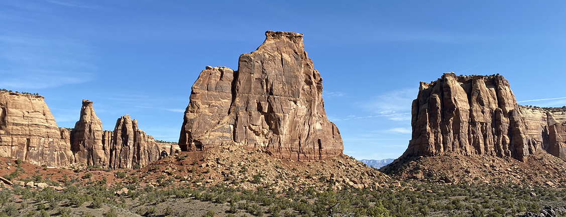
The first thing that stood out when descending the trail was the Coke Oven rock formation off to our right, facing south. We could see this rock formation for at least the next mile along the trail (pictured above).
Within the first 1/2 mile we had descended the most steep part of the trail and came across a beautiful high rock wall. You can see the stain marks from water flowing over the rocks during heavy rains.

There were so many incredible rock formations and I’m sure they all have names, but I’ll show some of them to you anyway.


This next rock formation looked really interesting and my daughter thought it looked like one of the characters in the Lord of the Rings movies. She called it Thorin OakenShield, from the Hobbit movies. Look closely, you’ll see the head, sword in the left hand and shield in the right hand. At least that’s what she saw.

We reached about half-way down the trail and came across some more great rock, and my daughter thought the second image looked like an alter up on top of the rock.

Instead of an alter, this may be called the Pipe Organ.

This next area is when we crossed over from the rock formations on the west side of the valley to the east side.

Here’s a nice panorama of the valley.

It was still early in the day in March, probably around 9 am, but the temperatures were starting to reach around 70 degrees.

The rock formations are plentiful and so magnificent.

I hope you’re not getting sick of all these pictures. We are nearly to the end of the trail but I still have a few more pictures for you.


My daughter thought this mountain in the middle of the next picture, jutting up out of the ground reminded here of Noah’s Ark.
We were finally approaching the bottom of the valley when we came across a frog or a fish. We couldn’t tell from looking at it’s face but when we walked around the back side, we could see it was shorter, like a frog.

Here are a few great panoramic photos and I believe the rock standing by itself is Independence Monument.


Here’s my last photo looking west from the lower valley, near the trailhead.

Trail Recommendations
This was a great trail but I would like to recommend a different trail for you. It is called the Monument Canyon Loop Trail. It is 4.5 miles long and makes a loop that is rated as moderate. This would be a better trail if you only have one car and don’t want to make the difficult hike back to the top of the Upper Monument Canyon Trail.
Lessons Learned
This part of Colorado can get extremely warm or hot in the summer months. We hiked it in March and it still reached 75 degrees by the time we finished the hike. My first recommendation is to hike it in the spring or fall when the weather is ideal. My second recommendation is to carry plenty of water with you in a daypack that is lightweight and perfect for this kind of hike.

- Dual-zippered access to main compartment
- External hydration sleeve accommodates up to a 3L reservoir (sold separately)
- Adjustable shoulder harness to dial in perfect fit
- Stretch mesh pockets on both sides of pack provide convenient storage for bottles and smaller items.
- Two zippered hipbelt pockets and LidLock helmet attachment
The other great thing about these day packs is you can carry a first aid kit, additional clothing or rain gear, binoculars, trekking poles and much more. It’s always best to be prepared on any hike or outdoor adventure.
Check out this short video of the Upper Monument Canyon trail on YouTube.
I would love to know if you have had any experience on this trail or have other trails you love to hike. Leave a Comment Below or send me an Email.
Return to Home Page
Upper Monument Canyon

Pros
- Incredible Drive
- Vast Rock Formations
- Rock Climbing
- Spectacular Views
- Warmer Climate in the Winter
Cons
- No Creeks or Lakes
- Hot in the Summer
- Potential for Rattlesnakes
Colorado has got some of the most beautiful places to hike in the world. The crisp (and thin) air and dramatic landscapes make for a memorable experience with breathtaking views (maybe that’s the thin air?? lol). I haven’t yet been to upper monument canyon, but this information is super helpful for planning the trip and knowing what to expect.
Gorgeous photos and tips. What are some of your favorite products that you would recommend to take on this trail?
Hi Aly. I’m glad you like the trail review.
I would recommend trail shoes or boots, backpack with plenty of water, along with sunscreen and a good broad rimmed hat, especially in the summer months. We always carry some trail bars, plus a first aid pack, and I always add a light weight rain jacket. I would also suggest a long sleeve shirt if you plan on hiking when the sun is coming up as the temperature can be cool in the mornings.
I hope that helps.
Rick
Wow! I have always wanted to go to colorado National Monument. What a ride you had! Wonderful pictures. Like coming into a mysterious world. The pipe organ was really nice! And the sun rise over the Rocky mountains. I would definitely pack my bacpack well. How much time did the hike take, and what time of year is best to go there?
The hike took us about 3 hours. It may be faster for some but we stopped to take a lot of photos and videos, plus on beautiful hikes, you should stop and enjoy the scenery more.
I think most people go in the summer months but personally, I like to go places when it is less crowded and the temperature is cooler. I would recommend spring or early fall. The only issue with spring and fall may be that some of the facilities aren’t open, however, the park and hiking trails look to be open year round.
Rick
Hi,
This was a really fun read from start to finish.
You provided a lot of information about the walking trails as well as helpful tips.
I really enjoyed looking at the photos.
The rock formations are spectacular.
I live in Scotland and while we have some amazing trails we don’t have the sunshine.
Best wishes,
Cameron
Hi Cameron. My wife and I want to visit Scotland some day soon. Your landscape and weather is different but that’s what’s so great about the world we live in. Thank you for stopping by and leaving a comment.
Rick
Hello there, thanks for this very informative post. I understand that for a post as detailed as this, there has to be a lot of conscious, calculated and deliberate effort put in bringing such together, and I must say that this is really a place to hike. My family and I have planned going on hiking this summer and I just think a place like this will be just perfect for us.
I’m glad you liked it and it’s helped you make some serious plans to get out and enjoy the outdoors. This has been one of our favorite hikes so far and it was an easy one. Hikes don’t have to be hard for them to be great.
Let me know how your summer hike goes.
Rick