Trail Information
Trail Name: Mount Rosa Trail
Location: Southwest of Colorado Springs, Colorado
Date: May 30, 2020
Time at the Trail Head: 6:00 am
Trail Length: 6.9 miles
Elevation Gain: 1,729 feet
Elev. at Trail Head: 9,790 feet
# of Hikers Passed: 70
# of Mnt. Bikers Passed: 1 (and 3 motorcycles)
# of Horses Passed: 0
Mosquitoes: 0
Trail Research
There has been a lot of rain in the forecast recently and the only place I could find, close by, that was sunny for the first part of the day was in the area of Colorado Springs, so I opened AllTrails and found the Mount Rosa Trail that is about 6.9 miles long, is rated as moderate and had a 1,700 foot altitude gain.

It looked promising, as it is in the Pikes National Forest, and is close to Pikes Peak, so I packed my backpack and made plans to head to the trail.
Drive to the Trail
I woke up early and had a great drive to the trail. The early morning hours are incredible with the sun rising and there are very few people out and about yet.
The drive to Colorado Springs was quick and soon I was driving by the Broadmore Hotel, as this is where the road leads into the mountains. It didn’t take long for me to have some opportunities for a few beautiful photos of the sun rising over Colorado Springs as I drove up into the mountains.

The trail was a long, slow, difficult drive up a dirt road with a lot of ruts, pot holes and wash boarding, that made the drive slow, but there were not many people out this morning so it was an okay drive.


We arrived at the trailhead just before 6 am and there were only a few cars parked at the trailhead. There are no bathroom facilities.


Someone was shooting some guns not far away and that way annoying but I figured we would get away from that after we headed up the trail a little way.
My Day on the Trail
The first 2 miles of the trail are on a 4-wheel drive trail, so go ahead and drive up it to save some hiking that isn’t that great. I was in a 2-whell drive truck and didn’t want to test it on this road. The entire 4-wheel drive road is not this bad but you can see there are some tough areas to get through.

There is a parking area and some camp sites farther up the 4-wheel drive road where you really start on the actual trail. The entrance through the fence is a little hard to see but they have limited the area you can fit through to stop 4-wheelers and motorcycles from reaching this trail (it wasn’t perfect because 3 motorcyclists made it onto the trail).

Ranger is such a great hiking buddy. He is always watching all around us and is alert to people and animals, which makes me feel much more comfortable when hiking.

It was at least 2.5 miles into the trail before we saw our first glimpse of some mountain peaks. Much of the trail is in the woods with no views of the mountains.


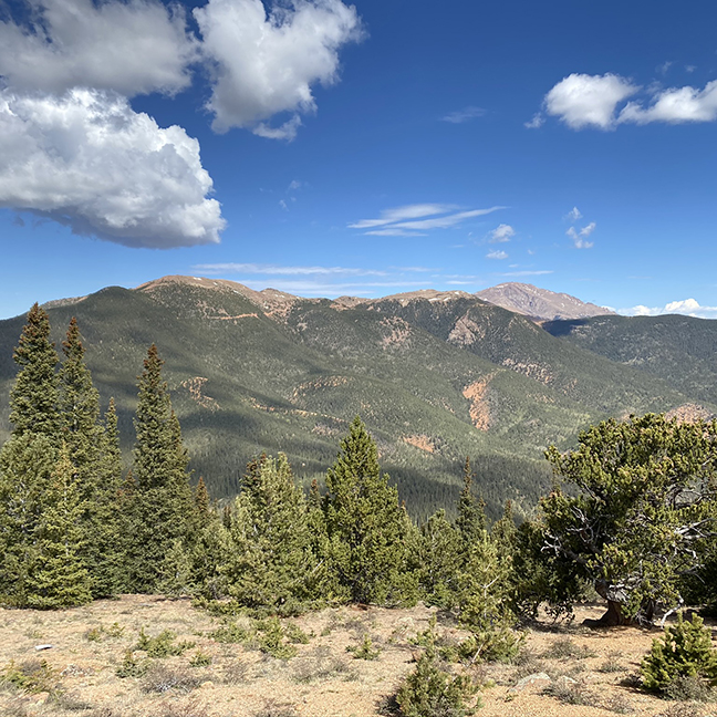
We were finally about 1 mile from the summit and were starting to see better views of the mountain range to the west, including Pikes Peak on the right side of the photo.

This next photo is of Colorado Springs with Chyenne Mountain in the foreground.

We only had about 1 mile remaining but had at least 500 feet to go and you can see the top of Mount Rosa below.

From this same area, you can get the best view of Pikes Peak to the northwest.

If you look closely, you can see a building on top of Pikes Peak which is a souvenir shop and restaurant.
We kept climbing and had more views of the mountains to the west, plus a small cloud started forming near Pikes Peak, and it kept growing into what looked like the beginning of a Thunderstorm, which you will see in a later photo.


These next few photos are looking south and you will see a reservoir in the second photo where the trailhead is on the north side of the lake.

This reservoir is called the Penrose – Rosemont Reservoir.

This next photo is looking southwest towards more of the Rocky Mountains in the distance.

Here are a few shots looking towards Colorado Springs.


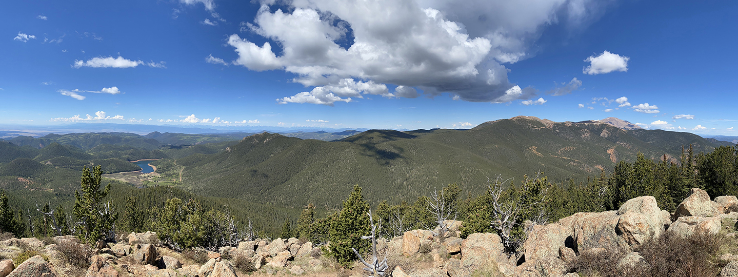
I finally reached the summit of Mount Rosa which sits around 11,500 high. Here is a great panorama photo from the top.

I was amazed at how many people were hiking the trail, which I counted at least 70 hikers, and you can see some of them at the top of Mount Rosa.

The clouds were starting to build quickly near Pikes Peak, which always gives me pause, due to the potential for lightning strikes.

Ranger and I started heading back to the trailhead but not before we took a few more photos.


Trail Recommendations
I cannot recommend this trail for several reasons and here are the primary reasons.
- Heavy hiking traffic
- Heavy 4-wheel drive vehicles on the 4-wheel drive road.
- Heavy shooting activity from at my best estimate was 30 or more groups using this area as a shooting-range.
There was so much 4-wheel drive traffic, over 70 hikers and massive amounts of gun shots going of in an area which has sighs saying no shooting.
Again, this trail is so close to a major city that it gets much more heavy traffic than trails that are over an hour away from the cities. My rule is to go at least 1.5 hours away from any major city.
Lessons Learned
I bought a great hiking shirt that I used for the first time on this trail. It was going to reach 70 degrees or higher on this hike but I wanted a long sleeve shirt, with a collar that was quick drying and had a lot of sun protection. I loved this shirt as it is soft, lightweight and was really comfortable, even when it started to warm up.
Check out this short video of the Columbia Silver Ridge Lite long sleeve shirt.

- ADVANCED TECHNOLOGY: This men's everyday flannel shirt features signature wicking fabric that pulls moisture away from the body so sweat can evaporate quickly.
- HANDY FEATURES: This men's cotton flannel long sleeve shirt features two chest pockets.
- ADJUSTABLE FEATURES: This men's flannel shirt features a front button closure and button-down cuffs for adjustable comfort.
- CASUAL FIT: With 100% cotton fabric, this men's flannel features a casual fit perfect for everyday wear.
- Columbia Men's Silver Ridge Long Sleeve Shirt is perfect for everyday wear.
Check out this short video of the Mount Rosa trail on YouTube.
I would love to know if you have had any experience on this trail or have other trails you love to hike. Leave a Comment Below or send me an Email.
Return to Home Page
Mount Rosa Trail
Pros
- Mountain Views
- Pikes Peak Views
- Close to Colorado Springs
Cons
- Difficult Dirt Road
- Heavy Hiking Traffic
- Heavy 4-wheel Drive Traffic
- People Use this Area as a Shooting Range
I have never been one to be interested in hiking but your photos and video made me want to start, but alas I am not able to climb. What sort of equipment or supplies do you take on a mountain hike like this? The terrain was so rough on the 4-wheel roads, what would help be available if one was injured from a fall and couldn’t finish the hike due to an injury? Like I said at first, your photos and video shots were absolutely breath taking. What type of cameras did you use? I’ll have to make plans to some day go to Colorado and see all the beautiful scenery.
Thank you for all of the questions. let me answer them one at a time.
1. Equipment? Backpack, waterproof boots, first aid kit, lot’s of water, hat for shade, good hiking pants and shirt, Garmin inReach Mini (for 2-way messaging & SOS function), waterproof jacket, snacks, trekking poles, and a few other misc. items.
2. Help if injured? There were a lot of other hikers on the trail so help would have not been a problem, however, I always carry the Garmin inReach Mini on my pack which let’s me message people and call for a search and rescue team if the worst would happen.
3. Camera? I use the iPhone 11X Pro. It has a much improved camera so as long as I can keep it charged, it handles all of my photos, videos and I also sync it with my Garmin which makes it easier to message people and look at my topo maps. The 11X Pro has a better battery than any of the past iPhones I have had, plus I carry a portable charger, in case I do run low on my battery.
I hope that helps. Let me know if you have any additional questions.
Rick